Showing 10 items matching mount bogong recreational activities
-
 Kiewa Valley Historical Society
Seal Skins Ski Straps / Soles, mid 1900's
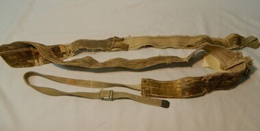
... mount bogong recreational activities.... alpine sports snow skis winter clothing mount bogong recreational ...These seal skin straps and webbing were introduced into the Victorian Alps by European engineers, conducting survey work for the SEC Hydro scheme in the late 1930s. This period in time produced many immigrants from a war torn Europe with highly developed technical skills. Many of these immigrants provided articles that were well suited to the alpine regions of Australia, ones they used in their homelands. These were times when the home grown cultures of the Anglo Saxon heritage of the earlier settlers within the Kiewa Valley became interwoven with the various European cultures and this formed, what in later years became the beginning of the Australian multi-cultural society. The Kiewa Valley and its surrounding regions where the major rural areas which did not progress in a so typical Aussie "dinky-di", "she'll be right" fashion. The European influence was however not too strong, so as to obliterate the flavour of the home grown rural society.The major populated sections of the upper Kiewa Valley and the Alpine regions were accelerated by the SEC Hydro Development which brought into the slow growing rural regions a quasi multi ethnic society, however this was only noticeable up to the time when the final Power Station was commissioned in the 1960s. The slight variations to the typical Australian rural settlements of the time were in some food preparations, winter apparel such as these seal skin straps and soles and "langlauf" (cross-country skis). The sealskins were sewn so that their grain ran from front to back thereby allowing the skins to grip going up hill and glide going downhill.The gardens and varieties of flowering shrubs and trees where also more in line with traditional European "outdoor" settings. Seal skin sewn onto one side of a strap of webbing. There is a webbing loop on the front that slips over a small point at the front of the ski. There is a webbing strap attached to the back of the seal skin sole coming over the back of ski that clips metal fasteners onto a loop of webbing behind the ski boot. alpine sports, snow skis, winter clothing, mount bogong recreational activities, snow sports -
 Kiewa Valley Historical Society
Photographs – Kiewa Cres Mt Beauty. Circa 1993. Set of 12 colour photographs
Established in 1946, during the construction of the Kiewa Hydro Electric Scheme, the township of Mt Beauty was developed by the State Electricity Commission of Victoria to provide additional accommodation for the thousands of workers during the construction of the country’s second largest hydro-electricity scheme. Although these towns were built as temporary accommodation for the workers and their families, many stayed after the scheme finished. Combined with the influx of European migrants, with their rich cultural backgrounds, all played a major part in shaping the future character of the Mount Beauty, the Kiewa Valley and Falls Creek. The Bright Council, now the Alpine Shire took over the control of the township in 1960. This relatively young town of Mount Beauty, along with the surrounding townships of Falls Creek, Bogong, Tawonga South and Tawonga, are all part of a prospering tourist area with excellent services, accommodation, food and a wide range of recreational activities available for all ages. According to Shire records, the population of Mt Beauty has grown from 1,500 in 1981 to 1,800 in 2016 with a projected increase to 2,000 in 2013The photographs taken around 1993 show a prosperous commercial centre catering for both locals and the needs of visitors. It provides a pictorial history of the changes which have occurred in the retail/commercial district of Mt Beauty over the years. It also demonstrates the attention paid by Alpine Shire towards providing accessible recreational green space around the town centre.Set of 12 colour photographs of Kiewa Cres Mt Beauty. Circa 1993 showing retail services and streetscape of the time. No markingskiewa cres mt beauty, mt beauty -
 Kiewa Valley Historical Society
Photographs – Lakeside Avenue, Mt Beauty. Circa 1993. Set of 7 colour photographs
Established in 1946, during the construction of the Kiewa Hydro Electric Scheme, the township of Mt Beauty was developed by the State Electricity Commission of Victoria to provide additional accommodation for the thousands of workers during the construction of the country’s second largest hydro-electricity scheme. Although these towns were built as temporary accommodation for the workers and their families, many stayed after the scheme finished. Combined with the influx of European migrants, with their rich cultural backgrounds, all played a major part in shaping the future character of the Mount Beauty, the Kiewa Valley and Falls Creek. The Bright Council, now the Alpine Shire took over the control of the township in 1960. This relatively young town of Mount Beauty, along with the surrounding townships of Falls Creek, Bogong, Tawonga South and Tawonga, are all part of a prospering tourist area with excellent services, accommodation, food and a wide range of recreational activities available for all ages. According to Shire records, the population of Mt Beauty has grown from 1,500 in 1981 to 1,800 in 2016 with a projected increase to 2,000 in 2013The photographs taken around 1993 show a prosperous commercial centre catering for both locals and the needs of visitors. It provides a pictorial history of the changes which have occurred in the retail/commercial district of Mt Beauty over the years. It also demonstrates the attention paid by Alpine Shire towards providing accessible recreational green space around the town centre.Set of 7 colour photographs of Lakeside Avenue, Mt Beauty. Circa 1993 showing retail services and streetscape of the time. No markingsmt beauty, lakeside ave mt beauty -
 Kiewa Valley Historical Society
Photographs – Tawonga Cres., Mt Beauty. Circa 1993. Set of 4 colour photographs
Established in 1946, during the construction of the Kiewa Hydro Electric Scheme, the township of Mt Beauty was developed by the State Electricity Commission of Victoria to provide additional accommodation for the thousands of workers during the construction of the country’s second largest hydro-electricity scheme. Although these towns were built as temporary accommodation for the workers and their families, many stayed after the scheme finished. Combined with the influx of European migrants, with their rich cultural backgrounds, all played a major part in shaping the future character of the Mount Beauty, the Kiewa Valley and Falls Creek. The Bright Council, now the Alpine Shire took over the control of the township in 1960. This relatively young town of Mount Beauty, along with the surrounding townships of Falls Creek, Bogong, Tawonga South and Tawonga, are all part of a prospering tourist area with excellent services, accommodation, food and a wide range of recreational activities available for all ages. According to Shire records, the population of Mt Beauty has grown from 1,500 in 1981 to 1,800 in 2016 with a projected increase to 2,000 in 2013The photographs taken around 1993 show a prosperous commercial centre catering for both locals and the needs of visitors. It provides a pictorial history of the changes which have occurred in the retail/commercial district of Mt Beauty over the years. It also demonstrates the attention paid by Alpine Shire towards providing accessible recreational green space around the town centre.Set of 4 colour photographs Tawonga Crescent, Mt Beauty. Circa 1993 showing retail services and streetscape of the time No markingstawonga cres mt beauty -
 Kiewa Valley Historical Society
Photographs – Holland Street North, Mt Beauty. Circa 1993. Set of 18 colour photographs
Established in 1946, during the construction of the Kiewa Hydro Electric Scheme, the township of Mt Beauty was developed by the State Electricity Commission of Victoria to provide additional accommodation for the thousands of workers during the construction of the country’s second largest hydro-electricity scheme. Although these towns were built as temporary accommodation for the workers and their families, many stayed after the scheme finished. Combined with the influx of European migrants, with their rich cultural backgrounds, all played a major part in shaping the future character of the Mount Beauty, the Kiewa Valley and Falls Creek. The Bright Council, now the Alpine Shire took over the control of the township in 1960. This relatively young town of Mount Beauty, along with the surrounding townships of Falls Creek, Bogong, Tawonga South and Tawonga, are all part of a prospering tourist area with excellent services, accommodation, food and a wide range of recreational activities available for all ages. According to Shire records, the population of Mt Beauty has grown from 1,500 in 1981 to 1,800 in 2016 with a projected increase to 2,000 in 2013The photographs taken around 1993 show a prosperous commercial centre catering for both locals and the needs of visitors. It provides a pictorial history of the changes which have occurred in the retail/commercial district of Mt Beauty over the years. It also demonstrates the attention paid by Alpine Shire towards providing accessible recreational green space around the town centre.Set of 18 colour photographs Holland Street North, Mt Beauty. Circa 1993 showing retail services and streetscape of the time. No markingsholland st mt beauty, mt beauty -
 Kiewa Valley Historical Society
Photographs – Holland Street South, Mt Beauty. Circa 1993. Set of 16 colour photographs
Established in 1946, during the construction of the Kiewa Hydro Electric Scheme, the township of Mt Beauty was developed by the State Electricity Commission of Victoria to provide additional accommodation for the thousands of workers during the construction of the country’s second largest hydro-electricity scheme. Although these towns were built as temporary accommodation for the workers and their families, many stayed after the scheme finished. Combined with the influx of European migrants, with their rich cultural backgrounds, all played a major part in shaping the future character of the Mount Beauty, the Kiewa Valley and Falls Creek. The Bright Council, now the Alpine Shire took over the control of the township in 1960. This relatively young town of Mount Beauty, along with the surrounding townships of Falls Creek, Bogong, Tawonga South and Tawonga, are all part of a prospering tourist area with excellent services, accommodation, food and a wide range of recreational activities available for all ages. According to Shire records, the population of Mt Beauty has grown from 1,500 in 1981 to 1,800 in 2016 with a projected increase to 2,000 in 2013The photographs taken around 1993 show a prosperous commercial centre catering for both locals and the needs of visitors. It provides a pictorial history of the changes which have occurred in the retail/commercial district of Mt Beauty over the years. It also demonstrates the attention paid by Alpine Shire towards providing accessible recreational green space around the town centre.Set of 16 colour photographs Holland Street South, Mt Beauty. Circa 1993 showing retail services and streetscape of the time. No markingsholland st mt beauty, mt beauty -
 Kiewa Valley Historical Society
Papers - Tawonga & Mt Beauty
Red Cross, CWA, Bowling Club histories in Tawonga and Mt Beauty written for a book, title unknown.The histories of the Red Cross, the Country Women's Association and the bowling clubs in the towns of Tawonga and Mt Beauty are important as the communities in the Kiewa Valley were involved in these organisations for many years from the mid 1940's and in the case of the Tawonga bowling club since 1953. The number of people, their activities and infrastructure associated with the clubs give an insight into how people lived during the times that the clubs existed.Papers from chapter 4 entitled 'Community Organisations' and chapter 5 entitled 'Recreational Activities & Opportunities' from an unknown book. These cover the townships of Tawonga and Mt Beauty and include black & white photos.red cross, country women's association, bowling clubs, mt beauty, tawonga -
 Kiewa Valley Historical Society
Photographs – Kiewa Cres Mt Beauty. Circa 1993. Set of 12 colour photographs, circa 1993
Established in 1946, during the construction of the Kiewa Hydro Electric Scheme, the township of Mt Beauty was developed by the State Electricity Commission of Victoria to provide additional accommodation for the thousands of workers during the construction of the country’s second largest hydro-electricity scheme. Although these towns were built as temporary accommodation for the workers and their families, many stayed after the scheme finished. Combined with the influx of European migrants, with their rich cultural backgrounds, all played a major part in shaping the future character of the Mount Beauty, the Kiewa Valley and Falls Creek. The Bright Council, now the Alpine Shire took over the control of the township in 1960. This relatively young town of Mount Beauty, along with the surrounding townships of Falls Creek, Bogong, Tawonga South and Tawonga, are all part of a prospering tourist area with excellent services, accommodation, food and a wide range of recreational activities available for all ages. According to Shire records, the population of Mt Beauty has grown from 1,500 in 1981 to 1,800 in 2016 with a projected increase to 2,000 in 2013The photographs taken around 1993 show a prosperous commercial centre catering for both locals and the needs of visitors. It provides a pictorial history of the changes which have occurred in the retail/commercial district of Mt Beauty over the years. It also demonstrates the attention paid by Alpine Shire towards providing accessible recreational green space around the town centre.Set of 12 colour photographs Kiewa Cres Mt Beauty. Circa 1993 showing retail services and streetscape of the time. No markingskiewa crescent mt beauty; shopping centre; -
 Kiewa Valley Historical Society
Maps - Bogong x2, Tawonga, Omeo, Dargo, Victoria and others, 1. Bogong Alpine Area; 2. Bogong 8324; 3. Tawonga Topographical; 4. Omeo 8433; 5. Dargo 8323; 6. Victoria State
1. Bogong Alpine Area (outdoor Leisure Map. survey & Mapping Victoria, Government of Victoria, Edition 2, reprinted 1991 with an image of Mt. Feathertop on the front. Information for tourist in the Alpine National Park: Bogong Area. Including: recreational activities, history, weather and vegetation and a list of walks together with locality maps and photographs. The front cover has an image of Mt Feathertop against a blue sky with yellow writing 'Bogong Alpine Area', there is a yellow triangular block on the right hand top corner with black writing 'Outdoor Leisure Map. On the bottom edge is a block of yellow with black writing 'Survey & Mapping Victoria' and a light green map of Victoria with 'VICMSP' printed in white. 2. 8324 Bogong Victoria, Edition 1, Commonwealth of Australia 1981. A topographical Map: 1:100,000 scale (1 cm to 1 KM). Map has a red cover with white writing together with a white block and black writing and a map insert. 3. Tawonga Topographical Map - Forests Commission Victoria, / revised 5/9/77, DEG No. 68-G/399. A Tawonga 803 folded map in a beige colour with the back blank. 4. Omeo 8433 Victoria, Edition 1, Department of Natural Resources. The map has a red and white cover with black writing and a simple map of Australia at the bottom. 5. 8323 Dargo, Edition 1, Commonwealth of Australia. A red and white cover with a map insert. 6. Victoria State Map, Hema Maps, 2002. Hema Maps, State Map, colourful cover with a map of Australia and four tourism photographs. Scale 1: 850,000 An inscription handwritten in blue pen "Trappers Gap to Mitta Mitta 1" to 1 mile". There are some pen markings and notations of tracks.maps, bogong, omeo, tawonga, dargo, victoria, bogong alpine area -
 Kiewa Valley Historical Society
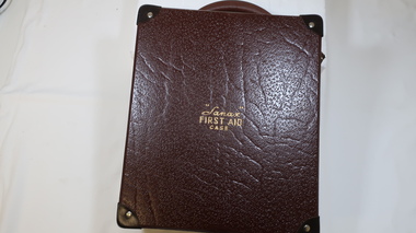
First Aid Case
Living, working, recreational activities in remote areas require precautions including a First Aid Kit.Brown rectangular case with a brown curved handle at one end and 2 clip fasteners at the front with a sliding lock fastener in the middle of them. All corners are reinforced. The inside has a lift out box, bandages, medication, tourniquet, snake/spider bite medication. There is a First Aid / Emergency / Instructions booklet inside the top of the case's lid.Outside on the lid: "Sanax" / First Aid / Casefirst aid kit, first aid case, sanax, remote areas